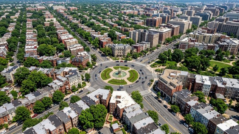
Welcome to Dupont Circle
Washington, D.C. buyers often focus their search on the blocks surrounding the famous traffic circle and its marble fountain. Dupont Circle, DC is a major residential and commercial hub located in the northwest quadrant of the city. The area features a mix of historic mansions, mid-rise condo buildings, and a dense concentration of local businesses.
Real estate here is defined by its walkability and immediate access to transit. You will find distinct micro-neighborhoods within the broader boundaries, each offering a different style of housing. Buyers moving to the area in 2026 often weigh these smaller enclaves against nearby options like Georgetown or Embassy Row.
Property values, transit routes, and local amenities vary from block to block. Understanding these local details helps buyers identify which specific streets match their budget and housing preferences. The 2026 market offers a range of options for those ready to purchase.
The community gathers year-round at the Sunday farmers market, which operates just outside the Metro station. Vendors from across the region set up tents to sell fresh produce, baked goods, and local crafts. This weekly event highlights the active, pedestrian-focused lifestyle that defines the area.
What to Expect When Living in Dupont Circle, DC
The neighborhood carries a Walk Score of 98, making it one of the most pedestrian-friendly areas in the capital. Residents can complete most daily errands without a car. Grocery stores, pharmacies, and hardware stores sit alongside upscale dining and retail along Connecticut Avenue.
Living in Dupont Circle, DC means sharing the streets with international embassies, think tanks, and private social clubs. This mix of commercial and residential zoning keeps the sidewalks active throughout the day. The layout branches out from the central traffic circle, with Massachusetts Avenue and Connecticut Avenue serving as the primary diagonal arteries.
Buyers looking at properties here should expect limited street parking. Many condo buildings offer deeded parking spaces, but these often command a premium on top of the purchase price. A dedicated parking spot can add $30,000 to $50,000 to a property’s final sale price.
Property taxes in the capital are calculated based on the assessed value of the home, which the city updates annually. Buyers should factor these annual tax bills into their monthly carrying costs when comparing properties. The local tax rate for residential property currently sits at $0.85 per $100 of assessed value.
Property Types and 2026 Real Estate Prices
The median home sale price in the neighborhood sits around $582,000 this year. This number is skewed by the high volume of one-bedroom and two-bedroom condos that change hands regularly. Buyers looking for detached houses or large townhomes will see much higher asking prices.
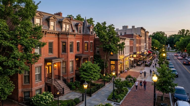
Single-family historic rowhouses frequently sell for $1.1 million to over $1.3 million. Renters entering the market can expect the average rent for a one-bedroom apartment to range from $2,500 to $2,700 per month. These figures reflect the premium buyers and renters pay for transit access and historic architecture.
Exterior modifications to these older properties fall under local historic preservation guidelines. Homeowners must secure approval from the local advisory board before changing facades, replacing original windows, or adding visible roof decks. Buyers should review these rules before planning any major exterior renovations.
Exploring the Strivers’ Section Micro-Neighborhood
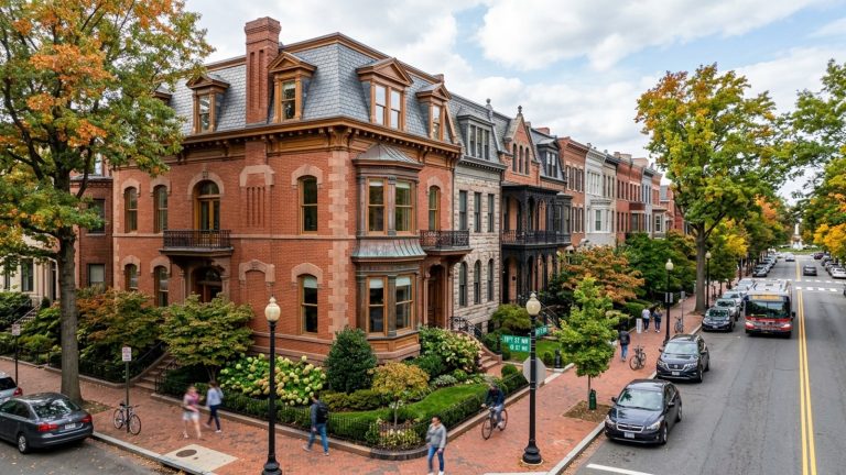
The Strivers’ Section is a designated historic district located in the northwest portion of the neighborhood. The boundaries roughly form a triangle between 16th Street, 19th Street, and Florida Avenue. This enclave offers a quieter residential atmosphere compared to the blocks immediately surrounding the central circle.
This area is known for its intact blocks of late 19th-century Victorian homes. Many of these properties retain their original architectural details, including prominent bay windows and ornate cornices. The streetscape looks much the same as it did a century ago.
Buyers touring homes here will notice narrow lots and multi-story floor plans. Many of the rowhomes feature English basements, which owners sometimes rent out as separate apartments to offset their mortgage costs. These lower-level units require specific certificates of occupancy to operate as legal rentals.
Local zoning laws prohibit most new construction within the historic district boundaries. Developers cannot tear down these historic rowhomes to build modern high-rises. This preservation strategy ensures the micro-neighborhood retains its 19th-century scale and architectural character.
Architecture and Historical Significance
Several homes in this district feature distinct Seneca sandstone facades. This red-hued stone was quarried locally in Maryland and was a popular building material in the capital during the late 1800s. You will also see intricate ironwork and steep slate roofs on many of the blocks.
The district holds deep historical importance as a residential center for upper-middle-class Black residents in the late 19th and early 20th centuries. Prominent civil rights leaders, educators, and politicians lived on these streets. Buyers interested in Washington, D.C. history often target this specific micro-neighborhood for its preserved legacy.
How Adjacent Neighborhoods Compare
Buyers searching in Dupont Circle, DC often expand their parameters to include the immediate surrounding areas. The borders between these neighborhoods blend together, but the housing options change as you cross them. Each adjacent community offers a different ratio of condos to single-family homes.
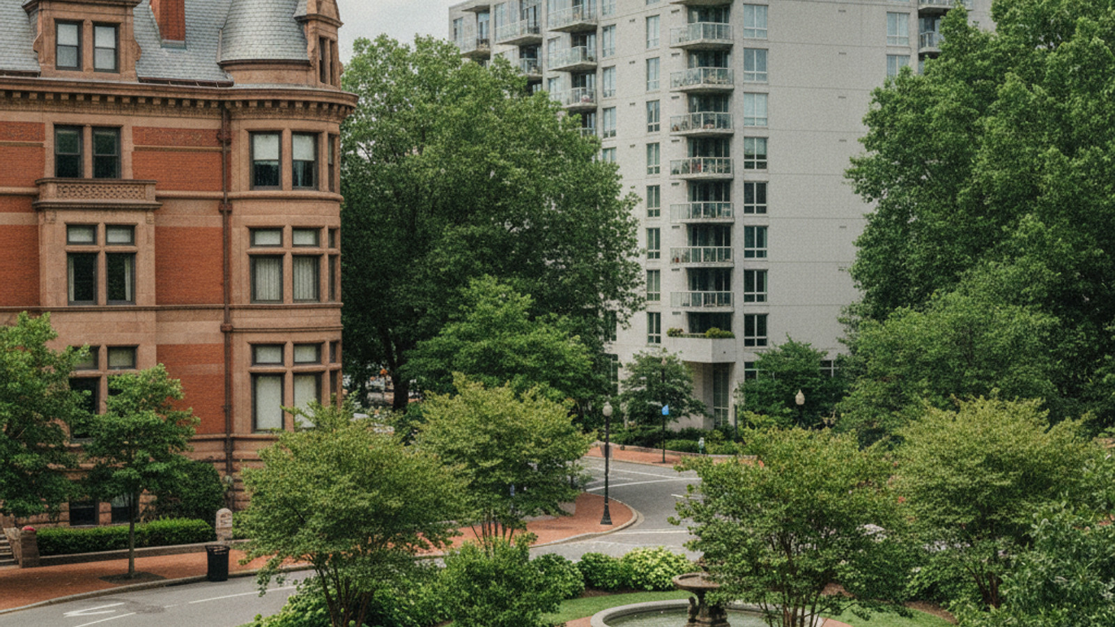
To the northwest, the Sheridan-Kalorama Historic District features larger, detached single-family homes and massive embassy properties. Properties in Kalorama routinely price well above the Dupont Circle median, catering to buyers with larger budgets. The streets here are wider and feature deeper front setbacks.
Comparing these adjacent zones helps buyers narrow down where they want to submit offers. A short walk across a neighborhood boundary can mean a difference in property taxes, condo association rules, and available square footage. The surrounding districts offer distinct alternatives for those priced out of the immediate circle.
Embassy Row stretches northwest along Massachusetts Avenue, connecting the neighborhood to the Naval Observatory. This corridor features massive limestone mansions that serve as diplomatic missions and ambassador residences. Real estate along this stretch rarely hits the open market.
West End and Logan Circle
The West End sits to the southwest and provides a stark contrast in housing styles. While Dupont Circle leans toward historic rowhomes, the West End is dominated by newer luxury condo buildings and high-end hotels. Buyers looking for modern amenities and floor-to-ceiling windows often prefer the West End inventory.
Logan Circle borders the area to the east and offers a similar mix of historic rowhomes and mid-rise condos. The residential layout in Logan Circle centers around the 14th Street retail corridor, which draws foot traffic for its restaurants and shops. This adjacent neighborhood provides a slightly newer commercial scene.
Adams Morgan and Woodley Park
Heading north across the Taft Bridge brings you to Woodley Park and Adams Morgan. Adams Morgan features a denser concentration of late-night entertainment and independent businesses. The housing stock there includes many cooperative apartment buildings alongside traditional condos.
Woodley Park offers a quieter, more suburban feel with its leafy streets and proximity to the National Zoo. Buyers prioritizing immediate access to large green spaces often look here as an alternative to the downtown core. The property lines in Woodley Park generally offer larger backyards.
Transit Options and Daily Commutes
The Dupont Circle Metro station sits at the center of the neighborhood beneath the traffic circle. This station operates on the Red Line metro, providing direct trains to Union Station, Bethesda, and Silver Spring. The station features two primary entrances, one on the north side of the circle at Q Street and one on the south side at 19th Street.
Surface transit is equally accessible for residents. Multiple bus routes travel along Massachusetts Avenue and Connecticut Avenue, connecting the neighborhood to areas without rail access. These bus lines offer a practical alternative during track maintenance or delays on the Red Line.
Cyclists use the dedicated bike lanes on 15th Street and other cross streets to move through the city. Capital Bikeshare stations are distributed every few blocks, allowing residents to rent bicycles for short trips. The relatively flat topography makes cycling a popular choice for daily errands.
Driving a personal vehicle through the area requires patience during rush hour. The traffic circle itself can be confusing for out-of-town drivers, and the surrounding diagonal avenues create complicated multi-point intersections. Most residents prefer to leave their cars parked and use public transit for their daily commutes.
Commute Times to Major Hubs
Commuting to Downtown Washington, D.C. takes about 10 to 15 minutes via the Red Line or a short bicycle ride. Walking to the downtown commercial district takes roughly 20 to 30 minutes depending on your exact starting point. These short transit times make the area popular with downtown office workers.
Reaching Georgetown requires a quick bus ride on the G2 line or a 25-minute walk across Rock Creek Park. Accessing Capitol Hill or the National Mall takes about 20 minutes using the Metro, making this location convenient for government employees and museum staff. Commuters heading to Virginia can transfer to the Orange or Silver lines at Metro Center.
Local Schools, Parks, and Retail
The neighborhood falls into specific public school boundaries, which buyers should verify during their property search. Certain addresses fall within the boundary for Ross Elementary School. This facility currently operates with a student-to-teacher ratio of 9:1.
Green space is integrated directly into the urban grid. The central fountain serves as a primary gathering space, with benches and grassy areas surrounding the traffic circle. Mitchell Park offers a recreation area tucked away in the northwest corner, featuring a playground and open turf.
For larger outdoor excursions, residents have direct access points to Rock Creek Park. This massive urban park features miles of paved trails, hiking paths, and sports facilities extending all the way to the Maryland border. Runners and cyclists use the park’s paved path as a continuous route through the city.
Dog owners utilize the S Street Dog Park, an enclosed run featuring artificial turf and water stations. Community gardens are also scattered throughout the surrounding blocks, allowing residents to cultivate small plots of vegetables and flowers. These small green spaces provide a break from the dense urban architecture.
Museums, Dining, and Bookstores
The area is home to several prominent cultural institutions. The Phillips Collection operates as an intimate modern art gallery housed in a historic Georgian Revival home. Nearby, the Heurich House Museum preserves the 19th-century mansion of a local brewing magnate.
The commercial corridors feature lots of restaurants, cafes, and independent shops. Connecticut Avenue serves as the main retail spine, hosting long-standing businesses like Kramerbooks. Known locally as Kramers, this independent bookstore and cafe has been a neighborhood fixture for decades.
Residents also have easy access to the broader cultural offerings of the city. A short Metro ride south brings you to the Smithsonian museums and the National Gallery of Art. The 17th Street corridor provides another strip of local dining options, including casual eateries and neighborhood taverns.
Frequently Asked Questions
What is the cost of living in Dupont Circle, DC?
Expect a premium price tag for housing, groceries, and dining compared to the national average. Condos form the entry point around $582,000, while detached rowhomes easily exceed $1.1 million. Monthly HOA fees in mid-rise buildings frequently add $500 to $900 to your carrying costs.
How walkable is Dupont Circle, DC?
The neighborhood earns a 98 Walk Score, meaning you do not need a vehicle for daily errands. Grocery stores, pharmacies, and the Red Line metro station are all located within a five-block radius of the central fountain. Sidewalks are wide, well-paved, and feature mature shade trees.
What are the best housing options in Dupont Circle, DC?
Your choices generally come down to historic rowhomes or condominium units. Buyers wanting original architectural details should target the 19th-century properties in the Strivers’ Section. Those prioritizing low maintenance and elevator access should look at the mid-rise condo buildings lining Massachusetts Avenue.