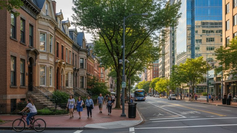
If you are thinking about living in Logan Circle, you are looking at one of the most centrally located neighborhoods in Washington, DC. It sits right in the geographic sweet spot of Northwest DC, bordering Downtown, Shaw, and Dupont Circle.
What makes this area unique is that while it doesn’t have a Metro station directly on the circle itself, it is arguably one of the most connected places in the city. Residents here enjoy a “Walker’s Paradise” lifestyle—boasting a Walk Score that usually hovers between 96 and 98—where owning a car is truly optional. Whether you are commuting to an office or just heading out for dinner, getting around is often faster on foot or bike than behind the wheel.
A Walker’s Paradise: Daily Errands on Foot
The reality of life in Logan Circle is that your feet are your primary mode of transportation. For the vast majority of residents, the daily routine of grocery shopping, grabbing coffee, and hitting a happy hour happens without ever swiping a Metro card or turning a car ignition.
The neighborhood is anchored by two major corridors. 14th Street NW acts as the main artery for retail and dining, lined with everything from fast-casual spots to high-end restaurants. Meanwhile, P Street NW offers essential services, including the fiercely popular Whole Foods, banks, and local pharmacies. Because the density of amenities is so high, the suburban concept of a “big box” driving trip just doesn’t apply here.
For those working in the central business district, the “foot commute” is a huge selling point. You can easily walk from your front door to an office on K Street or near the White House in under 20 minutes, bypassing rush hour gridlock entirely.
Nearest Metro Stations to Logan Circle
One of the most common questions from newcomers is, “Where is the Logan Circle Metro station?” The answer is that there isn’t one—but you are surrounded by a ring of them. This is actually a strategic advantage because it gives you walking access to every single Metro line without being tied to just one.
Residents typically choose their station based on where they are heading that day:
- McPherson Square (Blue/Orange/Silver): Located about a 10–12 minute walk south. This is your go-to hub for getting into Northern Virginia (Arlington, Rosslyn) or out towards Largo.
- Shaw-Howard U & U Street (Green): Roughly a 10–15 minute walk north or east. These are your best bets for heading to Navy Yard for a game or down to the Waterfront.
- Mt Vernon Sq (Green/Yellow): About a 10-minute walk southeast, offering easy access to the Convention Center area and lines heading toward Alexandria.
- Farragut North (Red): Approximately a 15-minute walk west. This is essential for trips to Union Station, Bethesda, or Friendship Heights.
Walking times obviously vary depending on which block you live on, but generally, you are never more than 15 minutes from a train.
Bus Routes & Connectivity
If walking to the train feels too far on a rainy day, the bus system here is robust and frequent. The neighborhood is threaded with key arteries that make cross-town travel surprisingly efficient.
The 14th Street Line (Routes 52 and 54) is the workhorse of the neighborhood. These buses run north-south constantly, connecting you all the way from Takoma down to L’Enfant Plaza. For east-west travel, the P Street Line (G2) is a local favorite, connecting the historic streets of Georgetown over to LeDroit Park. If you need to move faster north or south, the S-Line on 16th Street offers express options just a block or two away.
Local Note: You might see outdated guides mentioning the DC Circulator. As of December 31, 2024, the Circulator system ceased operations. Stick to the WMATA Metrobus routes mentioned above—they are reliable and cover the same ground.
Biking & Scooters: The 15th Street Cycle Track
For many locals, two wheels are better than four. Logan Circle is home to one of the city’s most vital pieces of cycling infrastructure: the 15th Street NW Cycle Track. This is a protected, two-way bike lane that runs north-south and serves as a major commuter highway for cyclists of all skill levels.
In addition to the main track on 15th, Q Street and R Street offer safer, lower-traffic lanes for cutting across town east-to-west.
You also don’t need to own a bike to take advantage of this. Capital Bikeshare has an extremely high density of docks in this area. Unlike some quieter neighborhoods where you might find an empty rack, it is rarely a struggle to find a bike or an open dock here. For shorter hops, electric scooters from companies like Lime, Spin, and Veo are almost always waiting on the street corners.
Driving & Parking in Logan Circle
If you are planning on bringing a car, you need to be prepared for the reality of urban parking. While it is possible to have a car here, it comes with logistical challenges and costs.
Most street parking falls under Zone 2 Residential Parking (RPP). As a resident, you apply for a Zone 2 permit, which is arguably the most valuable permit in the city because the zone is massive—covering not just Logan Circle, but also Dupont, Shaw, and parts of Downtown. However, competition for these spots is fierce. Finding a street spot after 7 PM can be a headache, and many residents spend time circling the block hoping for a departure.
If you want to avoid the daily hunt, off-street parking is the solution, but it carries a premium. Private garage spaces in condo buildings or rental apartments typically cost between $250 and $400 per month.
For guests, enforcement is strict. You will need to print a Visitor Parking Pass (VPP) from the city’s online portal or pick one up from the police station to keep your guests from getting ticketed.
Commuting to Key Employment Hubs
Because Logan Circle is so central, commutes are generally shorter than the regional average. Here is how most locals get to the major job centers:
- Downtown / K Street: The easiest commute of all. A 15–20 minute walk or a very short bike ride down the 15th Street cycle track.
- Capitol Hill: You can take the Blue/Orange line from McPherson Square, catch the 90/92 bus from the U Street area, or bike down Pennsylvania Avenue.
- Northern Virginia (Arlington/Rosslyn): A direct shot on the Blue, Orange, or Silver lines from McPherson Square makes this very predictable.
- Maryland (Bethesda/Silver Spring): The Red Line from Farragut North is your best direct link.
Walking times obviously vary depending on which block you live on, but generally, you are never more than 15 minutes from a train.
FAQs
No, there is no station named “Logan Circle.” However, the neighborhood is surrounded by four major stations (McPherson Square, Shaw-Howard U, Mt Vernon Sq, and Farragut North), meaning you are within a short walk of every Metro line in the system.
Yes, street parking can be challenging, especially in the evenings. While a Zone 2 Residential Parking Permit allows you to park in a large area, the density of residents means spots fill up quickly after work hours.
Absolutely. In fact, many residents find living car-free in DC is easier here than anywhere else. With a high Walk Score, excellent bike lanes, and multiple transit options, a car is often more of a burden than a necessity.
For most people, walking to the central business district or K Street takes about 15 to 20 minutes. It is often faster than driving once you account for traffic and parking.